A series of projects and planning initiatives are opening up new opportunities to develop underground space, raising expectations for a new “development layer” for Ho Chi Minh City.
Conditions converge for underground development
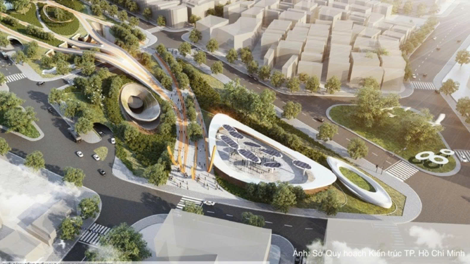
In early August, the planning scheme for the September 23 Park area in the former District 1 proposed a commercial and service complex, underground parking facilities, and a direct connection to Ben Thanh Metro Station, creating a multifunctional underground space in the heart of Ho Chi Minh City. Located in the city center, near Ben Thanh Market, Quach Thi Trang Square, and the Le Loi and Le Lai streets, the September 23 Park area is considered one of the locations with potential to connect to the city’s future urban railway network.
Overall perspective of Zone C – the second-prize-winning entry in the competition for ideas for the 1:500 detailed planning of the September 23 Park area.
Previously, the city also proposed an investment policy for the Ben Nha Rong - Khanh Hoi Cultural Park and Bach Dang Wharf public green space project. Under the plan, the project would include a pedestrian tunnel from the approach road to Tan Thuan 2 Bridge to Nguyen Van Linh Street, while part of Ton Duc Thang Street would be placed underground in line with the planning for the Bach Dang Wharf area, helping ease traffic congestion and improve transport connectivity.
The Bach Dang Wharf area would also feature underground parking facilities and an underground shopping center, alongside landscape improvements, green spaces, a docking platform and viewing decks. Under the proposed schedule, construction would run from the third quarter of 2026 to the second quarter of 2029.
Another project is the Can Gio - Vung Tau sea-crossing road, which is approximately 14.06 km long and designed with six lanes, including more than 8 km of sea-crossing bridge and 3.85 km of undersea tunnel. On July 1, Ho Chi Minh City broke ground on Component Project 1, the access road on the Can Gio side. Meanwhile, Component Project 3, comprising the bridge and undersea tunnel and regarded as the most complex part of the project, is currently undergoing the completion of its feasibility study by the investor and consultants for submission to the city for approval and further implementation.
These projects indicate that underground space is increasingly being viewed not merely as technical infrastructure for transport, but also as part of the urban structure, where commercial and service activities, transport facilities and public amenities can be developed.
This direction has also been incorporated into the city’s long-term planning vision. Resolution No. 09-NQ/TW, dated May 19, 2026, of the Politburo on building and developing Ho Chi Minh City in the new era calls for integrated planning and development of different types of space, including underground, green, river-and-water, marine, low-rise and high-rise spaces. Meanwhile, the Urban Development Law, which will take effect on October 1, will provide an additional legal basis for the management, development, exploitation and use of underground, low-rise and high-rise spaces.
Most recently, at a consultation conference on the master plan for Ho Chi Minh City with a 100-year vision, underground space was again identified as a new resource and development space for the city.
Expectations for a global urban landmark
In an interview with Newspaper of Industry and Trade, Dr. Architect Nguyen Bao Thanh of the Faculty of Architecture at Van Lang University said traffic pressure in the city was creating a need to find additional development space beyond the ground level. The number of vehicles in the city has reached an overloaded level, while metro lines currently in operation and under development cannot immediately ease all surface-level pressure. Expanding road space is also increasingly difficult due to limited land availability and high site-clearance costs.
“Road coverage in Ho Chi Minh City is only about one-fourth of international standards. If we continue expanding roads, compensation costs would be difficult to afford,” Thanh said.
Against this backdrop, Dr. Nguyen Bao Thanh said developing underground space could create additional room for transport, freight logistics and commercial activities, while generating revenue to recover investment costs for underground infrastructure and metro projects.
Rather than continuing to concentrate more functions at ground level or expanding vertically, utilizing underground space could increase floor area within the same land plot. Thanh said this approach could also be studied and piloted in several central areas of Ho Chi Minh City, Thu Dau Mot and Vung Tau.
“This could become a distinctive feature of the city in the future. Above ground, we are working to improve and upgrade existing structures. But the city could truly establish a global competitive identity by developing underground space,” Dr. Nguyen Bao Thanh said.
According to research by experts from the Faculty of Architecture at Van Lang University, Ho Chi Minh City currently has 12 areas in the central region with potential for underground commercial development, with the number potentially rising to 23 areas following the consolidation. The research team has also proposed connecting 31 renovated old apartment buildings with underground commercial facilities as part of a network linking high-rise buildings and shopping centers.
Drawing on existing conditions and international experience, the research team has proposed developing a dedicated Law on Underground Space Management for the Ho Chi Minh City metropolitan area, based on the principle of spatial layering.
Under the proposal, the shallow layer, from 0 to 15 meters underground, would accommodate pedestrian traffic, small-scale commercial activities, parking facilities and basic infrastructure such as water supply and drainage. The intermediate layer, from 15 to 40 meters, would be used for major public transport facilities, shopping centers and cultural amenities. The deep layer, more than 40 meters below ground, would accommodate major technical infrastructure, flood-control facilities and strategic national projects.
According to Dr. Thanh, Ho Chi Minh City needs to develop an underground spatial data map as soon as possible to prevent one project from interfering with another and facilitate connections between existing areas and new developments.
From a technical perspective, the expert said many parts of Ho Chi Minh City could support underground development, but a key requirement is comprehensive and synchronized data. A clear understanding of what exists underground would enable planners to avoid conflicts between infrastructure projects while creating opportunities to connect existing underground spaces with newly developed areas.
In their research, Dr. Nguyen Bao Thanh and his co-authors have proposed an investment and implementation roadmap for underground development across the Ho Chi Minh City metropolitan area through 2050, with total investment estimated at VND 855 trillion. The roadmap focuses on research and completion of the legal framework, development of a comprehensive 3D map, construction of 10-15 km underground connecting routes, integration with eight metro lines, and the goal of establishing a “fifth development layer.”
The ASEAN Economic Ministers’ Meeting highlighted positive progress in economic integration, trade, digital economy and stronger connectivity among ASEAN economies.
The Prime Minister has asked relevant ministries and agencies to urgently finalize draft laws and resolutions to mobilize resources for socio-economic development.
General Secretary and President To Lam’s attendance and address at UNGA 81 high-level debate are particularly significant as Viet Nam and the UN look ahead to the 50th anniversary of their relations.
A series of projects and planning initiatives are opening up new opportunities to develop underground space, raising expectations for a new “development layer” for Ho Chi Minh City.
Industry and Trade Newspaper would like to introduce a podcast series on the implementation of the Politburo's Resolution No. 57 in the Industry and Trade sector.
The programme connects Vietnamese businesses with Chinese investors, expanding opportunities for investment, technology cooperation and supply chain links.
The MoIT calls for proactive risk management and supply diversification to prevent energy supply disruptions amid global geopolitical and market uncertainties.
On September 14, in Hanoi, the Ministry of Industry and Trade (MoIT) held a conference to receive and hand over State management functions and tasks concerning geology, minerals and industrial parks.
Deputy Minister of Industry and Trade Nguyen Sinh Nhat Tan has been reassigned and appointed to the Executive Committee and Standing Committee of the Ho Chi Minh City Party Committee, and appointed Deputy Secretary of the Ho Chi Minh City Party Committee for the 2025 - 2030 term.
A green industrial ecosystem, capable suppliers and synchronized infrastructure are emerging as new requirements for Viet Nam to attract the next generation of foreign direct investment (FDI).